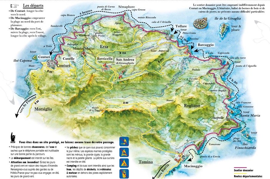
This article will explain you how to hike the 12-kilometer section of the Sentier des Douaniers from Macinaggio to Barcaggio with return loop; while it is worth discovering all the “Sentier des Douaniers” network of dirt paths, this particular hike is the undisputed highlight, guiding walkers through sun-baked scrubland, past half-ruined maritime towers, and straight to the northernmost horizon of the island. For you I went Hiking the path from Macinaggio to Barcaggio, making a complete loop. Follow me on this fascinating hike!
Essential Trail Logistics
Before you lace up your shoes, you need to know how to get there, how to get back, and what to expect on the ground.
🧭 Trail Overview
- Type: Coastal Path; there is NO shaded area
- Starting Point: Macinaggio Marina (large parking areas available near the port).
- Ending Point: Barcaggio fishing village.
- Distance: 12 km (7.5 miles) point-to-point.
- Difficutly: Easy to Moderate (mostly flat, but exposed to sun and rocky in places)
- Time Needed: 3.5 to 4.5 hours of pure walking time. Allow 5.5 hours to include swim stops and exploring the Genoese towers.
- Terrain: Rocky coastal dirt tracks, sandy dunes, and short, steep climbs over jagged schist ridges.
- Best Time: Spring (wildflowers) or Autumn (warm water, fewer crowds)
Visualizing the Route
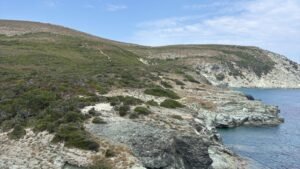
The trail hugs the very edge of the coastline, winding through the scrubby Mediterranean maquis (shrubland), past hidden beaches, and historical ruins.
How to get there
- 🚗: To reach Macinaggio by car from Bastia, you will take a straightforward and scenic coastal drive straight up the eastern coast of Cap Corse. Follow the D80 highway (Route du Cap) for 37km straight into the marina village of Macinaggio.
- 🚌: The bus departs in Bastia, with stops in Sisco, Pietracorbara, Porticciolo, Santa Severa andMeria. Check for schedules ahead of time.
The path starts at the Macinaggio Beach; park your car in the Public Parking of the Marina, and head towards the Nautical Club, where you will see the first sign.
Practical Tips for the Reader
There is almost zero shade. My best advice is to pack twice as much water as you think you need and a hat. Take some breaks and go for a swim but remember that the Med is quite salty and can be irritating when drying on your skin. There are absolutely no beach shacks, springs, or cafes along the 12-kilometer stretch. You must carry all your supplies. Bring at least 2 to 3 liters of water per person, plus snacks to sustain you for 5 hours.
Skip the flip-flops. While it is a coastal path, it is not a flat boardwalk. You will encounter loose gravel, sharp rocks, and steep inclines (especially up to the Agnello Tower). Sturdy trail runners or lightweight hiking shoes with good grip are highly recommended to avoid slipping.
Try to start As early as possible. The trail faces north/northeast and offers almost no shade. In the summer, starting by 7:30 AM or 8:00 AM allows you to complete the bulk of the walking before the punishing midday sun hits the exposed coastal cliffs.
The Past of the Sentier
Created in 1791 following the French Revolution, the path was originally carved along the coastline to help armed customs officers (douaniers) patrol for illegal smugglers trading contraband in the island’s hidden coves. Guards walked these lonely, wind-swept beats day and night for over a century until modern maritime security left the trail obsolete, allowing the thick Mediterranean overgrowth to reclaim it. In the late 20th century, the historic route was cleared and restored, transforming a path once used for tax enforcement into one of Corsica’s most scenic, peaceful hiking trails.
Trail Highlights: Where Wild Nature Meets Genoese History
What makes this stretch of the Sentier des Douaniers unforgettable isn’t just the panoramic Mediterranean views—it’s how seamlessly the path weaves through centuries of coastal history and pristine natural reserves. As you wander along the rugged shoreline, keep an eye out for these signature landmarks.
Plage de Tamarone: The Gateway to the Wild
Leaving the marina of Macinaggio, the trail rolls gently through low, aromatic coastal brush before dropping you onto the wide crescent of Tamarone Beach. Known as one of the most beautiful bays in Cap Corse, its deep turquoise water contrasts sharply with the pale sand. It is the perfect place for a quiet morning swim before the real trekking begins.
Depending on the season, you may find thick, soft mounds brown “debris” lining the water’s edge. That is dried Posidonia oceanica, a Mediterranean seagrass. While it can sometimes look unappealing to visitors, it is proof of a highly healthy marine ecosystem. It protects Corsica’s stunning beaches from winter wave erosion, so please respect it! This natural buffer preserves the shoreline and sets the tone for the undeveloped, wild landscapes ahead.
The Historical Treasures (The Middle Stretch)
This is the heart of the hike where the scenery gets dramatic.
The Finocchiarola Islands & Nature Reserve
As the path climbs slightly higher onto the rocky headlands, look out to sea to spot the Îles Finocchiarola. The mini-archipelago is easily visible from the trail. Perched dramatically on the highest point of the outermost islet stands the ruined base of a 16th-century Genoese watchtower, silently keeping guard over the marine passage just as it did hundreds of years ago.
This cluster of three jagged islets is a strictly protected nature reserve, serving as a critical nesting sanctuary for the rare Audouin’s gull.
Tour de Santa Maria: The Split Tower in the Sea
The absolute crown jewel of the hike is the Tour de Santa Maria (also known as the Tour de Santa Maria della Chiappella), a highly photogenic spot! Unlike most Genoese towers that sit high on rocky cliffs, this striking stone monument stands directly in the shallow, crystalline shallows of the bay. The ruin is split down the middle but hasn’t lost anything of its grandeur.
The tower’s unique appearance is unforgettable: a vertical slice is completely missing, exposing its ancient interior chambers to the sea elements. This dramatic damage dates back to 1794, when British naval ships under the command of Admiral Nelson bombarded the coast. Just inland from the tower, don’t miss the crumbling stone arches of a 10th-century double chapel, partially reclaimed by the surrounding maquis shrubland.
The Wild North to Barcaggio
Tour d’Agnello: The Panoramic Apex
The final major historical marker before your descent into Barcaggio is the Tour d’Agnello. Getting to it requires a short, heart-pumping climb up a steep, rocky ridge, but the payoff is immense.
This circular watchtower is beautifully preserved and occupies a commanding position on the northernmost tip of the peninsula. From here, the views explode into a 360-degree panorama: looking back, you can trace the entire jagged coastline you just traveled, and looking forward, the distant, low profile of the island of Giraglia rises from the deep blue sea.
La Pointe du Cap
As you pass the Tour d’Agnello, you reach a defining geographical milestone: the Capicorsu —the literal crown of Corsica. This is the most septentrional (northernmost) point of mainland Corsica. Standing on these weather-beaten rocks feels like standing at the literal edge of the world. Just two kilometers off the coast, the islet of Giraglia rises from the sea, topped by its famous, lonely white lighthouse. Looking out into the infinite blue where the Ligurian and Tyrrhenian seas collide, there is a profound sense of isolation and beauty that perfectly captures the spirit of slow travel.
Arriving in Barcaggio
Mostly known today for its marina, the charming fishing village has a sleepy, end-of-the-world atmosphere , but You would be surprised how much history the hamlet hides behind its quietness; You can read more about Barcaggio here ! For now,there are two important features worth mentioning besides the fact that it is the arrival point of your hike
- You can witness A Rare Geological Phenomenon: While massive sand dunes are quite common in the south of Corsica or across the desert-like Agriates region, they are exceedingly rare on the rocky, jagged coast of northern Cap Corse. The Barcaggio dune system is uniquely shaped by competing maritime forces. It features a low-lying beach dune that rolls into two parallel dune crests, culminating in a rare “wind-plastered” dune (dune plaquée) pressed against the inland hills by the powerful, sweeping northern winds. The entire dune field is highly protected under the European Natura 2000 network and managed by the Conservatoire du Littoral (Coastal Protection Agency). The sand is stabilized by a incredibly fragile network of native vegetation, most notably marram grass (oyats), which anchors the shifting sand with its deep roots, alongside rare sea daffodils that bloom in the late summer heat. Because the ecosystem is so delicate, hikers are strictly required to stay on the designated trail paths to prevent the wind from rapidly eroding the unprotected sand.
- The locals cows sunbathing on the sand at Barcaggio: Warning !! These iconic quadrupeds are semi-wild livestock. They are used to hikers but can become aggressive if they feel cornered. Keep a respectful distance (at least 20 meters), never approach a calf, and do not try to pet or feed them.
The Return Journey: How to Get Back
- ⛴️ Check the Boat Schedule First: Do this a day before. The seasonal shuttle boat U San Paulu is the easiest way back. It sails from Barcaggio back to Macinaggio in about 1 hour. Schedules are available from April 10 to October 10 and vary depending on the month, with up to 4 departures in each direction. Check schedules online or at the Macinaggio port office—they change depending on the month.
- 🎟️ Book Your Tickets in Advance: Crucial in July & August. Don’t assume you can just hop on. Spaces are limited. Book your return ticket before you start walking to guarantee your seat on the final boat of the day. Good news if you hike with your 4 🐾 friends, they are allowed onboard!
- 🌬️ Monitor the Wind: Morning of the hike. Cap Corse is notoriously windy. If the sea is too rough, the shuttle boat will be canceled for safety. Check with the boat operator or port morning-of.
- Have a Backup Plan: In case of cancelation. If the boat is grounded, your options are a 4-hour walk back the way you came, return by bus, or calling a local Cap Corse 🚕. Keep a local taxi number saved in your phone just in case. Count about 50€ for 4 people.
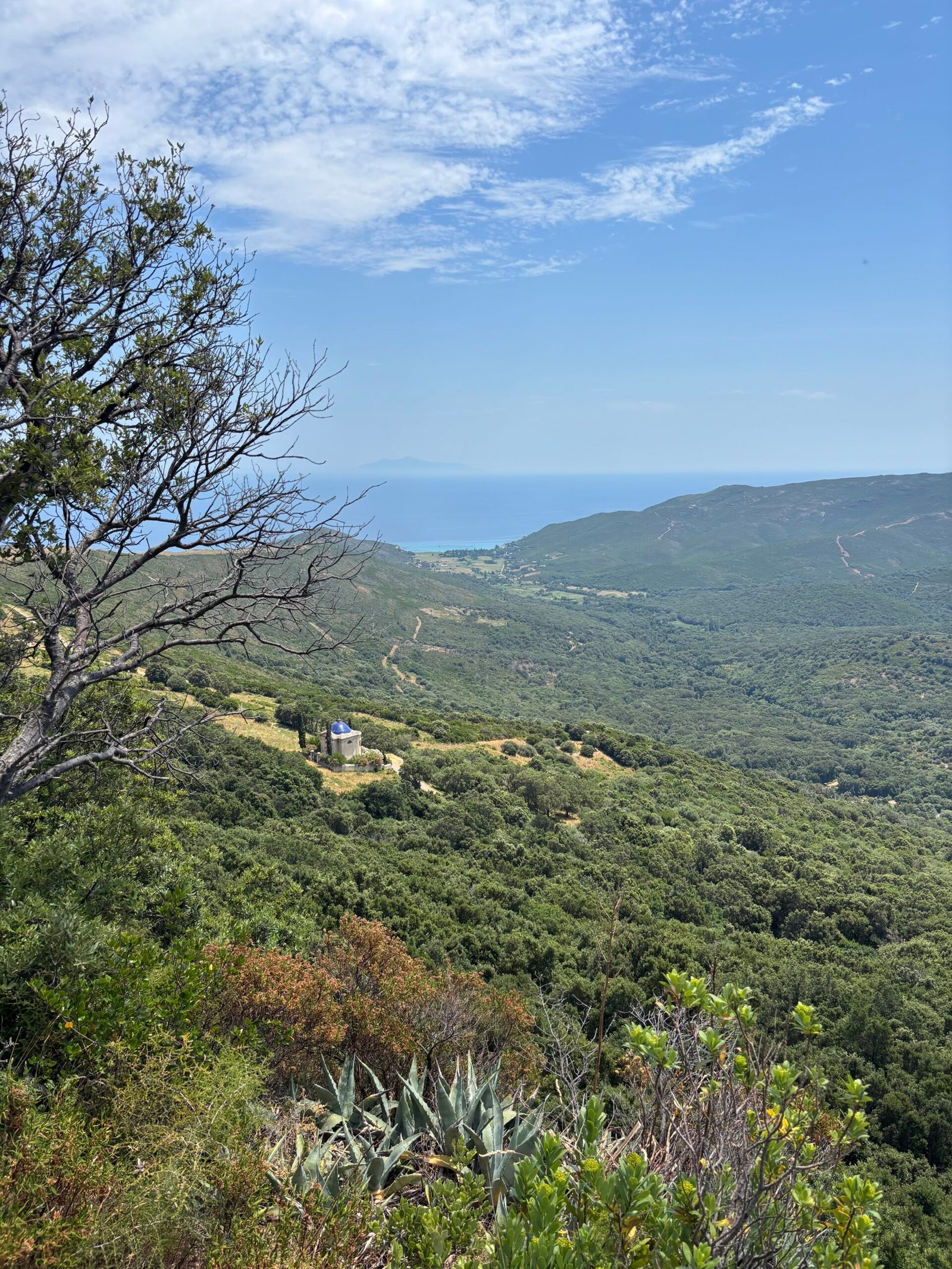
The Way Back: Venturing Inland
If you are in for more, you can walk your way back to Macinaggio
If you choose to skip the shuttle boat and walk back, a secondary path cuts directly through the hills, twisting this point-to-point hike into a full, self-contained loop. Leaving the coast behind means stepping into a completely different sensory world. The open sea views vanish, replaced by the dense, sun-warmed walls of the maquis—Corsica’s wild Mediterranean shrubland—which fills the air with the rich, earthy scent of wild rosemary, myrtle, and rockrose. This interior trail offers a quiet, deeply peaceful contrast to the exposed cliffs of the morning. It traces old rural tracks through the heart of the peninsula, bypassing the crowds and leading you steadily back down to the familiar sands of Tamarone Beach. From there, it’s a gentle, easy stroll along the water’s edge to finish the loop right where you started at the Macinaggio marina.
I am sure you still have time for a well deserved ice cream!